Chapter 2 HighRoad tutorial - Part 2
![]()
In preparation for the next part of the tutorial you should create another file to work with.
Note: If you have taken a break between tutorial sections, you first need to open the appropriate file.
* Open the file named Tutorial Part 1.rdd.
* Choose Save as... from the File menu.
* Name the file Tutorial Part 2.rdd.
Once you have completed the terrain model of your survey you can begin to work on your design. There are three main elements in designing a road:
* the horizontal alignment
* the vertical alignment
* the typical section.
Each road you design is represented by a control line. The plan view will show the horizontal alignment of the control line. The profile will show the vertical alignment (elevation) of the control line. The typical section will determine the shape of the surface of the road. In this example you will design two roads.
* Choose New control line... from the Plan menu.
A dialog box as shown in Figure 2-5 will appear.
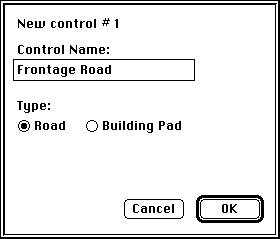
* Type Frontage Road in the dialog box.
* Click OK.
Designing the horizontal alignment
You can now enter the horizontal alignment of the road. This road will run along the frontage of the subdivision and will replace the existing road, which is displayed on the terrain model using feature strings. The horizontal alignment is entered in the Plan window using the mouse. It must be drawn within the outside edge of the terrain model.
* Choose the scale 1:500 from the View menu.
* Scroll the Plan window so that the lowest part of the terrain model is visible.
Note: If you have a large screen, the window will be sized to fit the screen and the plan will be displayed at a scale that just allows all points to be visible. The scales referred to here may not be appropriate.
* Choose New IP from the Plan menu.
The cursor will change to a cross when it is over the Plan window.
* Click in the lower right area of the terrain model, just above point 52.
A small circle (![]() ) will be drawn here to
represent the horizontal intersection point (IP).
) will be drawn here to
represent the horizontal intersection point (IP).
* Choose New IP from the Plan menu to add another IP.
* Click and drag the IP to a position just below point number 80.
A line will be drawn to the first IP as you drag the pointer.
* Release the mouse button when the IP is positioned at the desired location.
Once you have positioned the horizontal alignment of the new road you can design the typical section, view the profile along this alignment and design a trial gradeline.
Tools used to design a typical section
* Select Typical Section from the Window menu.
A window named Frontage Road Typical Section 1 of 1 will appear on your screen. This window is similar to the others, having a title bar and scroll bars, but it also has a palette of HighRoad tools on its left side. These tools are used for designing typical sections. The icons in the tool palette represent edges (for example, kerb and gutter) and surfaces (for example, pavements).
* Double-click on each icon for further information.
A dialog box will appear with details of the name and dimensions of each tool that you choose. These details and dimensions can be changed to suit your purpose.
* Click OK to remove the dialog box from the screen.
The marker in the centre of the window represents the control line (or centre line) for the road, with the small horizontal bar representing the level of the control line.
Designing a typical section
* Choose 1:100 scale from the View menu.
* Click the left kerb and gutter icon (
) to select it.
The pointer will change to the shape of the kerb and gutter icon when you move it into the blank part of the window. The icon in the palette of tools will be highlighted.
* Click the pavement icon (
) to select the pavement type.
The pavement icon in the palette of tools will be highlighted. The cursor should still be a kerb and gutter shape.
* Position the cursor to the left of the control line. Drag the cursor to a position 3.5 m to the left of the control line with a crossfall of 3.0%.
HighRoad will draw the pavement from the control line to the lip of the kerb and gutter, displaying the offset and crossfall of the pavement. As you drag, HighRoad will update the drawing to show the new location of the kerb and gutter.
* Release the button when the pavement is in the right location.
Note: If you release the button before the pavement is located correctly you can change it. Click on the offset or crossfall of the pavement you have drawn. A dialog box will appear. You can type in the required offset and crossfall.
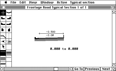
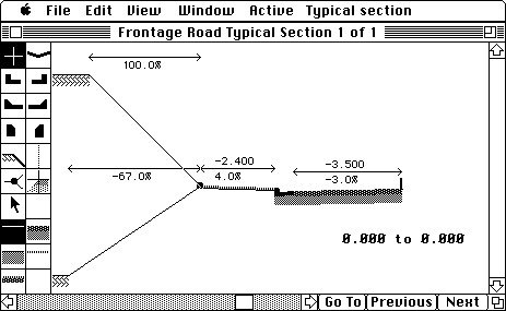
Your typical section should now be similar to Figure 2-6. All surfaces and edges can be placed in a similar manner using the appropriate tools on the palette. The next task is to add the footpath to the typical section. This will be link number 2. (Links are numbered in the order in which they are entered.)
* Click on the cross cursor (
).
The cross cursor is used where no edge is required.
* Click on the grass surface (
) to select the surface type.
* Position the cursor and drag it to the correct location (2.6 m offset, 4.0% crossfall).
* Click on the split point (
), then move the cursor so that it is just to the left of the last link added and click.
A large dot will appear at the edge of this link.
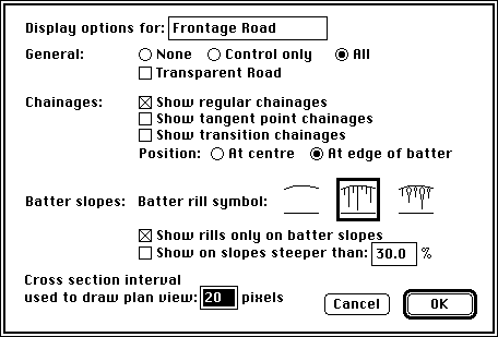
* Click on the batter point (
) and the untreated surface (
) to locate the cut and fill batter slopes as shown in Figure 2-7.
Note: If you make an error while setting up the typical section, correct it.
* Choose Undo from the Edit menu.
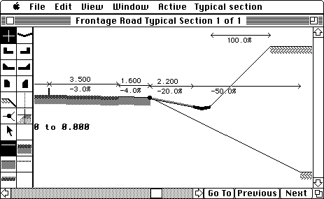
You have entered four links so far, all on the left hand side of the typical section -- the road pavement, the grassed footpath, the cut batter and the fill batter. The split point is not regarded as a link. Continue to design the right hand side of the typical section, using the following outline as a guide to each new link. The right hand side of your typical section should look similar to that shown in Figure 2-8.
|
Link |
Side |
Edge |
Surface |
Width/Location |
Crossfall |
|
5 |
RHS |
|
|
3.500 |
-3% |
|
6 |
RHS |
|
|
1.600 |
-4% |
|
|
|
|
|
|
|
|
7 |
RHS |
|
|
2.200 |
-20% |
|
8 |
RHS |
|
|
Upper |
100% |
|
9 |
RHS |
|
|
Lower |
-50% |
Chainage range
It is necessary to specify the length of the road over which this typical section applies.
* Click on the text 0.000 to 0.000.
A dialog box will appear so that you can specify the chainage range.
* Change the range so that it is from 0.000 to 100.000. Click OK.
The chainage range should now appear on the screen under the typical section you have designed. You can now enter the vertical alignment of the road.
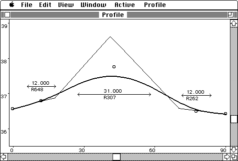
Viewing the profile
* Select Profile from the Window menu.
* Select 1:500 from the View menu.
Note: The Profile window is preset with a vertical exaggeration of 1:10. In this instance, the vertical scale is 1:50.
The profile will be redrawn at the new scale. The profile on your screen should look similar to that shown in Figure 2-9.
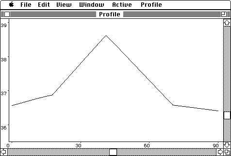
Note: Because the ground profile will be drawn along the horizontal alignment you have chosen, it may be slightly different to the profile shown here.