|Creative Engineering
home page|
|Table of contents |
Learning HighRoad |
Using HighRoad|
Reference|
| Previous |
Next |
Chapter 3
Survey data
This chapter shows you how to bring survey data into HighRoad. You
will learn how to import survey data from a variety of sources and
how HighRoad uses the data.
Format of survey
data

Survey data used by HighRoad is normally in the format of an
irregular network of points. Survey data in point format is imported
into HighRoad via a text file. A new text file can be created by
typing in data from a keyboard. Alternatively the text file can be
transferred from another source, for example, a survey data logger,
or another program. The text file of point data can be in many
different formats such as DXF, CivilCAD, MOSS, NTF, compass and
clinometer or data logger readings.
Note: HighRoad also handles survey data in the
form of cross sections. This method is explained in
Chapter 21,
Cross section survey, page
21-1 .
Figure 3-1

Point
data -- via a text file

Entering survey points from the keyboard
On opening HighRoad, select New to start a new project. A dialog
box as shown in Figure 3-1 will appear.
Select Irregular network of points - from keyboard.
Alternatively, if you are already working in HighRoad, choose Text
from the Window menu. An empty document will be displayed.
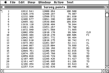
Type in the data for each point in the following order: point
number, northing, easting, elevation and comments. Separate each item
with one or more spaces or a single Tab. Start a new line for each
point. Your text file should look similar to that shown in
Figure 3-2. Choose Save As... from the File
menu to save the text file.
Note: You can type data in any of the formats
that HighRoad understands. This format is the simplest and most
readable.
Figure 3-2
Transferring data from a text file
For most users this will probably be the most common form of
survey data. On opening HighRoad, select New to start a new project.
A dialog box will appear (see Figure 3-1).
Choose Text file and a file selection dialog box will appear. Open
the text file you require. Alternatively, if you are already working
in HighRoad, choose Text from the Window menu. An empty document will
be displayed. Choose Open Text File... from the File menu.
Transferring data from a data logger
You can transfer data directly from a data logger into a text
file. Before you begin you need to turn off your computer and connect
your data logger to the communications serial port of your computer.
Note:
Some computers do not have a built-in serial port. Serial devices are
available from various suppliers and can be fitted to PCI slots and
PC Card slots as well as USB ports. For connection to data loggers
which generally come standard with a DB9 connector, it is advisable
to choose a serial port such as as the KeySpan PDA Adaptor which has
a matching male DB9 connector.
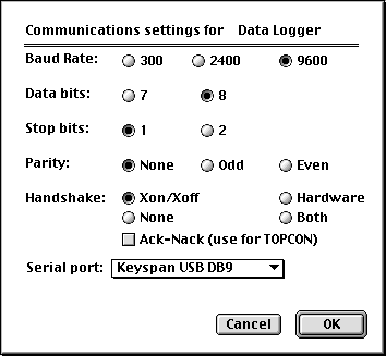
Set up the data logger so that it is ready to transmit survey
data. Choose Read Data Logger... from the File menu. A dialog box
will appear which allows you to select the communication settings on
your computer that match your data logger (see
Figure 3-3). Click on the Serial port box to
bring up a list of serial ports and select which type of serial port
you are using. There is also a check box to enable Ack-Nack protocol
for use with TOPCON devices. For SDR we recommend using Xon-Xoff for
handshake. Click OK.
A blank document will appear on the screen ready to receive the
data transmitted by your data logger. A progress box will also be
displayed showing whether the computer is waiting on or receiving
data from the datalogger. You can now initiate data transmission from
the data logger. If you want to stop transmission of data from the
data logger click Cancel in the progress box. Once the data has been
transmitted it is ready for conversion. (See
Converting a text file, page
3-5.) If you want to save the
text file first choose Save As... from the File menu.
Figure 3-3
Importing data from DXF files
HighRoad requires the terrain information in digital form as three
dimensional points. HighRoad can convert both 2D and 3D DXF files.
2D DXF files do not store the elevation of the contours, which is
an essential piece of information needed by HighRoad. You need to
make use of layers to transfer this. You must create or change the
DXF file so that each contour is on its own layer. As each layer is
to represent an elevation, choose a suitable name such as Contour 10,
Contour 15, Contour 20 and so on. (You will need this information
when HighRoad is converting the file.)
Each contour line should be a polyline. Other information such as
property boundaries and buildings can also be transferred using
polylines. HighRoad will convert POLYLINE, LINE and POINT entities.
Some DXF files use LINE entities for individual point data. When LINE
entities are used to represent points, both the start and end point
are the same. HighRoad checks for this and if this is the case, only
one point is created. Again, each type of information should be on
its own layer.
Note: Refer to Technical note #1: Techniques for
importing data from 2D DXF files for more information on how to set
up a suitable DXF file.
3D DXF files include elevation data so layers are not needed for
elevations. Layers are still useful for feature lines such as
buildings and property layers.
Importing data from CivilCAD files
The data from CivilCAD has to be a CivilCAD Version 4 ASCII file
to be able to be read into HighRoad.
Note: Consult Technical note #5 Transfer of
CivilCAD data for details.
Importing data from MOSS files
The data from MOSS has to be in MOSS GENIO format to be able to be
read into HighRoad. This is a GENeral Input
Output format used by MOSS.
Note: Consult Technical Note #6: Transfer of data
from MOSS for details.
Converting a text
file

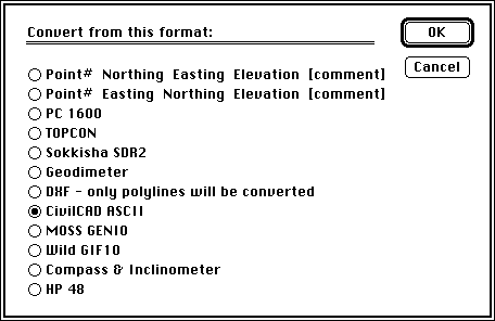
Text files must be converted into HighRoad format before you can
create contours or design a road. Choose Convert Text File... from
the Edit menu. A dialog box as shown in Figure
3-4 will appear.
Select the appropriate setting for the file format. Further
information about converting files from other sources (data loggers,
DXF, CivilCAD and MOSS) is given below.
Figure 3-4
Files from data loggers
Files from data loggers may require more information.
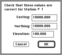
During the conversion process you will be asked to check that the
location and elevation of the stations are correct. A dialog box (see
Figure 3-5) will appear for each station,
with values for Easting, Northing, and Elevation. (For the first
station the Easting and Northing are set at 10,000.00, the Elevation
at 100.00.) If you wish to use other values, change them.
Figure 3-5
For all subsequent stations, the location and elevation is that
calculated by HighRoad from the previous station. The Eastings and
Northings are taken from the previous foresight to this station.
These values are NOT corrected by comparison with a backsight to the
previous station. The elevation is calculated using the average level
difference between the foresight to this station, and the backsight
to the previous station. If you wish to use other values, type them
in here and click OK. Data logger files may include co-ordinates
already reduced by the total station. In this case the co-ordinates
do not have to be calculated by HighRoad.
DXF files
To transfer the data in a DXF file into HighRoad, select New to
start a new project. A dialog box will appear -- select DXF file. You
will be presented with a standard file selection dialog box from
which you can select the DXF file you wish to open. During conversion
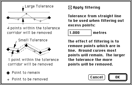
of DXF files, points on a polyline can be filtered to reduce the
number of points needed to create the model. Check the box labelled
Apply filtering in the dialog box that appears during conversion of
the DXF file. See Figure 3-6 for details.
Figure 3-6
Another dialog box (as shown in
Figure 3-7) will also appear giving you the
option to set the scale and units of measurement. Co-ordinates are
required in real world units. Some DXF files may have to be scaled to
achieve this. Set the scale if necessary. Choose the appropriate unit
of measurement.
Figure 3-7
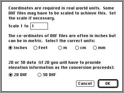
DXF files can contain 2D or 3D data. Choose 2D or 3D as
appropriate. HighRoad will then scan the DXF file looking for
polylines. If the data is 3D, the elevations of polyline points will
be contained in the data. HighRoad will ask for information about
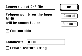
each polyline (see Figure 3-8).
Figure 3-8
If the data is in 2D format the elevations of points on a polyline
will be provided by you, based on the layer name as explained
previously in Importing data from DXF files, page
3-4. HighRoad will ask for information
about each polyline as shown in Figure 3-9.
Figure
3-9
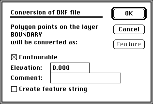
Use this dialog box to specify the elevation of points
so that a terrain model can be created from 2D contours. You can make
each polyline contourable, add a comment or create a feature string
from each polyline. Check the box labelled Create feature string. The
Feature button will be enabled. Click this button to specify the
details of the feature string. You would probably not want to create
feature strings from contour lines. Polylines that represent
buildings, fence lines, property boundaries etc. should be converted
as features. (For more details about features strings see Adding
feature strings automatically, page
4-2.)
CivilCAD files
The data from CivilCAD has to be a CivilCAD Version 4 ASCII file
to be able to be read into HighRoad. Start up HighRoad, click New and
select Text from the dialog box that appears. Select the file that
you wish to convert. Choose Convert Text File from the Edit menu and
then choose CivilCAD ASCII from the dialog box that appears. HighRoad
will translate this file, displaying a box to indicate that the
translation is progressing. Once the translation is complete, a Plan
view of the job will appear, showing any features that have been
converted. CivilCAD ASCII files include information about whether
each point is contourable or not. CivilCAD considers that points
marked contourable and with an elevation of -10000 are actually
non-contourable. HighRoad understands this quirk.
MOSS files
Start up HighRoad, click New and select Text from the dialog box
that appears. Select the file that you wish to convert. Choose
Convert Text File from the Edit menu and then choose MOSS GENIO from
the dialog box that appears. HighRoad will then proceed to translate
this file, displaying a box to indicate that the translation is
progressing. Once the translation is complete, a Plan view of the job
will appear, showing any features that have been converted. MOSS
strings are considered to be joined, contourable, and breaklines
unless the elevations are -999 metres, in which case they are
considered as non-contourable points, or the string name begins with
P, in which case they are considered as individual points, not joined
as a feature. The MOSS string name (four characters) will be used for
the name of the feature.
Uploading
points to a data
logger

If your data logger is not already connected, you need to turn off
the computer and connect your data logger to the communications
serial port of your computer. For computers that do not have a serial
port, refer to note on page 3-3.
Preparing points for upload to a data logger
To prepare points for upload to a data logger, select which points
you want to upload.
Note: If no points are selected in the Plan
window, all points on the plan will be listed. If a feature is
selected, the points on that feature will be listed in order along
the feature. Points on a feature list only in Tab delimited or
TopCon format.
Figure
3-10
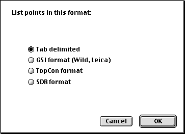
Select List Points from the Text menu and a dialog box as shown in
Figure 3-10
will appear. From this box choose the format you require (tab
delimited, GSI (Wild, Leica), TopCon and SDR (Sokkisha, Sokkia)) to
suit upload to your data logger. Click OK. The points listed in the
text window are ready for upload.
Note: The formats tab delimited, GSI and SDR all
list one point per line with tabs between the point data. TopCon uses
a less readable, but more compact format. The tab delimited format
may be suitable for use with a range of data loggers.
Exporting points to a data logger
Choose Upload to datalogger from the Text menu. A dialog box will
appear which allows you to select the communication settings on your
computer that match your data logger (see
Figure 3-11. Click on the Serial port box
to bring up a list of serial ports and select which type of serial
port you are using. There is also a check box to enable Ack-Nack
protocol for use with TOPCON devices.
Figure
3-11

Note: The latest computers may not have built-in
serial ports. Add-on serial ports are available and can connect via
USB connectors, PCI slots, or PC card slots, as applicable for
different computers. For serial ports added in this manner, proceed
as outlined above. Individual manufacturers supply the necessary
drivers for their serial port.
Click OK and the data logger should be ready to accept data. If no
response is received on the serial port after 90 seconds, the upload
is abandoned.
Note: Some data loggers and instruments can
accept PC Memory Cards (sometimes known as PCMCIA cards). To upload
data to these dataloggers the text file should be saved, and copied
onto the PC card. Many notebook computers are fitted with PC card
slots, and others can be fitted with external PC card readers.
| Previous |
Next |
Copyright 2001 Creative Engineering